Phase 2 signage completed

photo of signage at the corner of Amstel Ave. and South Main St.
Westbound on Amstel Ave. at South Main St.

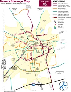
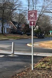
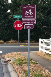
Just before the new year, the City of Newark completed installation of wayfinding signage for the West Bikeway segment of the Newark Bikeways low-stress network.

photo of view in the railroad tunnel looking west
Westbound entry to Hillside Park from the railroad tunnel

This work came on the heels of the opening of the long-awaited Hillside Park, built on the former grounds of the University of Delaware’s Rodney residence halls complex.

photo of signage in Hillside Park looking toward Dallam Rd.
Westbound Hillside Park sign looking onto Dallam Rd.

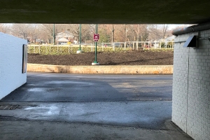
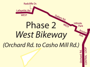
As a result of this work, bicyclists can take a low-stress route from Orchard Road on the Central Loop westward to Casho Mill Road—down Amstel Ave., through the railroad tunnel, Hillside Park, and the Oaklands and Nottingham Green neighborhoods.

photo of signage at end of West Bikeway
Terminus of the West Bikeway at Casho Mill Rd.

On Casho Mill Road, just south of the end of the bikeway segment is John R. Downes Elementary School. This segment should be widely used by elementary school children who can bike to/from school through the neighborhoods it bisects. Buffered bike lanes on Casho Mill Road will help keep young bicyclists safe on the short ride to/from Lafayette Road.

photo of destination signage eastbound on Dallam Rd.
Destination signage eastbound on Dallam Rd.

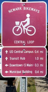
Eastbound (i.e., toward the city center and Central Loop Bikeway), signage includes directional symbols or destination information.

graphic map of the West Bikeway
Map of the West Bikeway segment

Thanks goes to Delaware Greenways for its generous grant to BikeNewark, which partially funded our “phase 2” signage—for the North, Northwest, and West Bikeways segments—as well as to the White Clay Bicycle Club for its monetary support, and to the City of Newark for installing the signage.

Signs for 3 new Bikeways

Coming soon to Newark!

Planning is now underway for implementation of the wayfinding signage for the next three segments of the Newark Bikeways low-stress network. BikeNewark is working with the City of Newark to complete this second phase of its network wayfinding project. Routes along existing low-stress roads and pathways will soon be signed and connect to the Central Loop Bikeway—the network hub, the signs for which were installed in 2019.

graphic of North, Northwest, and West Bikeways signsFunding for signage for the project’s second phase, which includes the North, Northwest, and West Bikeways, was secured with proceeds from the 2019 Community Fun Ride event, as well as a recent grant from the Delaware Greenways’ Future Trails of Northern Delaware Coalition (FTNDC).

In fact, BikeNewark received from the FTNDC an unexpected 66% more in funding than it had requested. Why?  Executive Director Mary Roth of Delaware Greenways (one of BikeNewark’s partner organizations) explains:

graphic of Newark Bikeways map“BikeNewark made a request of $1,508.87 with matching funds drawn from BikeNewark’s prior events and donors,” Roth said in a recent email to BikeNewark chair Bob McBride. “Our committee felt strongly that we should fund the project with the maximum grant possible of $2,500, giving [BikeNewark] more of an opportunity to continue the work of this and future phases.”

photo of “Central Loop” sign
sign example (NB on Orchard Rd. at Winslow Rd.)

BikeNewark will begin an effort to garner funding for the final, albeit most-prolonged, phase of the project, which will include the Southwest, Northeast, South, and East Bikeways (see Bikeways map).

BikeNewark’s Engineering Committee will begin planning wayfinding for the Southwest Bikeway segment over the next few months, in anticipation of the completion this year of DelDOT’s Elkton Road off-road bike/ped pathway, part of its major overhaul of Elkton Road from Gravenor Lane to the Maryland state line.

Unsolicited Project Kudos

Thank you for all of your work over the years to improve the bike trails and signage to make Newark such a bike-friendly place. From my house, I bike to the underpass by Amstel Avenue then take Orchard to Phillips Park to access the Hall Trail. As someone who is just getting comfortable riding on roads, the Newark [Bikeways] signage helped me find the access point from Ritter Lane. I now feel safe making a big loop from the Hall Trail to the Pomeroy Trail to Creek Road. I’m a very cautious biker, so these low-stress routes have enabled me to really enjoy& biking safely in Newark. Thank you!

—a female Newark resident in her 30s

Exercise in Newark while social distancing

Check out Newark’s low-stress Central Loop Bikeway.

photo of bicyclists on Central Loop (Pomeroy Trail)Feeling restless at home? Want to get some outdoor exercise at appropriate social distances? Consider dusting off that bike in your garage and heading out along Newark’s recently signed Central Loop Bikeway*.

Wayfinding signage was introduced along this bikeway last fall as phase 1 of a multi-year project to develop a connected network of paved roads and trails in Newark, which is designed to encourage use of low-traffic, low-stress streets and off-road multiple-use pathways (like the popular James F. Hall Trail) by bicyclists of all ages.

photo of bicyclist reading wayfinding signage on Hall TrailBikeNewark has been and is working with the City of Newark’s Department of Public Works & Water Resources staff as well as its Department of Parks & Recreation to plan a network of eight bikeways. These will enable low-stress connections to in-city destinations and trails outside of Newark (such as those in White Clay Creek State Park). BikeNewark plans for its phase 2 signs to be implemented this year, comprising three new bikeways. See Bikeways plan (PDF).

photo of wayfinding signage on Orchard Rd. northbound at Winslow Rd.Newark Bikeways will also serve as the way through Newark for the East Coast Greenway (“ECG” on the signs), a designated bicycle corridor from Maine to Florida.

Local or visiting cyclists will be able to use the Newark Bikeways system as a way to travel around Newark for shopping, work, or recreation. Bicycle-specific signs designed by the Delaware Department of Transportation (DelDOT) are placed to guide them along the mix of paved off-road trails and city streets. DelDOT generously contributed the cost of the Central Loop Bikeway signs.

Phase 2 signage is being made possible through proceeds from last September’s Community Fun Ride as well as generous contributions from former Newark Mayor (and BikeNewark member) Polly Sierer and the White Clay Bicycle Club.

BikeNewark is helping raise funds to cover costs of signage for the additional four planned Bikeways routes (phase 3). If you’re interested in helping fund this project, see BikeNewark.org/donate.

The nonprofit BikeNewark is a partnership of interested cyclists and organizations working to improve bicycling in Newark, Delaware, and a founding member of The Newark Partnership.


graphic of Central Loop Bikeway
Central Loop Bikeway

*Note: The Central Loop includes a portion of Delaware Avenue, which we understand can’t be considered “low stress” at this time and can only legally be ridden by bicycle eastbound. When DelDOT’s next major work project in Newark is complete, Delaware Avenue will feature a two-way protected bikeway, which will make the Central Loop completely low stress in both directions.

Urgent support needed for bridge project

City Council meeting this Monday, July 8, at 7 p.m.

engineering artist's rendering of Emerson BridgeThe White Clay Creek/Emerson Bicycle and Pedestrian Bridge Cost Estimate and Funding is on the agenda for the Monday, July 8, Newark City Council meeting. The Emerson Bridge will be located over the White Clay Creek immediately west of the existing Paper Mill Road vehicular bridge (see figure above).

The meeting will be held at the City of Newark Municipal Building, 220 South Main Street and the will begin at 7:00 p.m. Along with Council voting on allocating additional funding for the project, there will also be discussion on potential cost saving measures that was a part of value engineering completed for the project. One of the potential cost saving initiatives includes a reduction in the width of the proposed 194 ft.-long structure from 12 ft. to 10 ft. for a $60,000 savings. Attached is informational material on the project that was included in a public workshop that was held in April.

This will likely be the last time you will be able to comment on the bridge project with City Council.

Newark Bikeways map detail showing Bridge project and proposed conduit trailNote: The current plans contain no physical connector to the Pomeroy Trail, which is part of our proposed Newark Bikeways low-stress network; however, we’re told it is included in the city’s 2021 Capital Improvement Project budget. We’d also like your support for voicing the need for associated funding for this paved off-road conduit from the Pomeroy Trail to the bridge approach pathway (see figure), so that low-stress connections can be made to the Newark Reservoir and trails beyond.