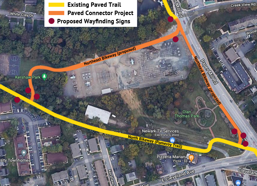
Following the 2022 completion of the Emerson (bike/ped) Bridge, the City is moving forward with plans to have DelDOT construct two off-road paved trails, one through Kershaw Park and the other through Olan Thomas Park, which will connect the bridge with the Pomeroy Trail.
The project began in January 2023 with a meeting of engineering representatives from Pennoni Associates, City staff, and members of BikeNewark to discuss design project issues and parameters.
Along with generous funding from New Castle County, project funding had been earmarked in the City’s 2023 budget. It is anticipated that this project will be completed in 2026.
This project has long been in BikeNewark’s plans for connecting the bridge to its North Bikeway and adding wayfinding signage north and east through Curtis Mill Park and along Old Paper Mill Road, thus completing the Northeast Bikeway segment of the Newark Bikeways low-stress network.
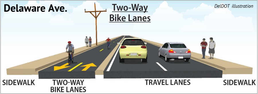
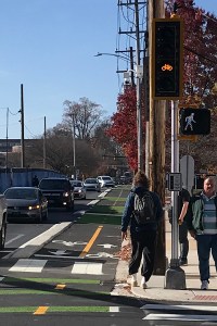
On Thursday, November 10, 2022, DelDOT officially opened to bicycle traffic the completed two-way protected bikeway (a.k.a. cycletrack) on Delaware Avenue. Eight days later on November 18, dignitaries came together for an official ribbon-cutting ceremony.
DelDOT diagram of the two-way protected bikeway infrastructure on Delaware Avenue
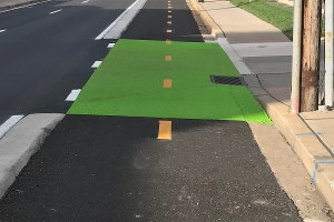
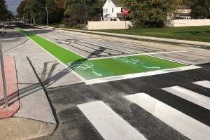
Solid green surface treatment in conflict zones
This brought to a close a nearly $8 million project that was first thought about in the 1990s, included as a recommendation in the 2014 Newark Bicycle Plan, and advocated for by BikeNewark’s predecessor entity in 2014.
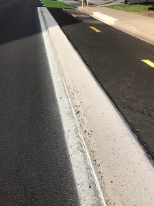
Protective beveled concrete curbing separating bikeway from vehicle travel lane
The primary motivation for such a project was to provide a safe, legal way for bicyclists to move westbound through Newark’s downtown area. Previously, the only legal way for bicyclists to get from Library Avenue or Kirkwood Highway to South Main Street, West Main Street, or New London Road was to use Cleveland Avenue or East Main Street—both higher-stress options for cyclists, even with the recent improvements to those two major streets.
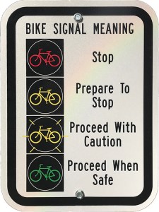
Bicycle-specific traffic signals in both directions along bikeway
Amenities for bicyclists along Delaware Avenue that were included in this project:
Bike-signal sign explaining red, yellow, flashing yellow, and green signals
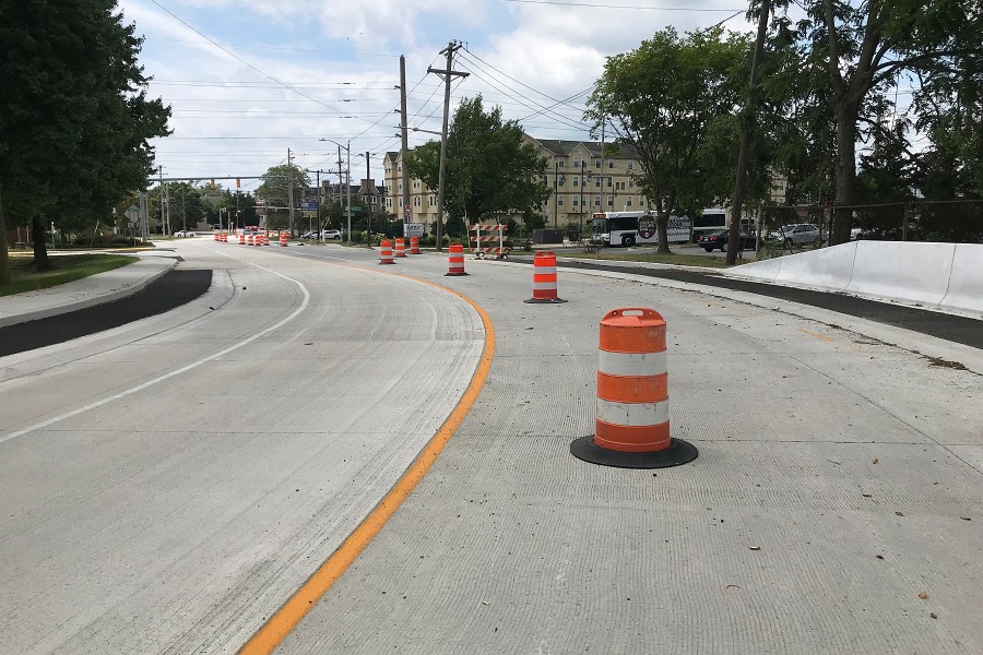
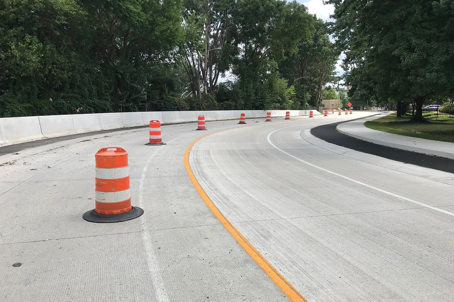
a two-way protected bikeway from Orchard Road to the Pomeroy Trail, separated from the traffic lane by a 3-inch-high beveled concrete barrier
one-way elevated bike paths on either side of the road from the Pomeroy Trail to Library Avenue
separate bicycle-specific traffic signals in both directions
green surface paint through intersections and at conflict points (e.g., driveways)
bike boxes at the eastern and western ends of the project (Delaware Avenue / Library Avenue intersection and the Amstel Avenue / South Main Street intersection)
Bike box at Library Avenue intersection
This completion of this project finishes the final segment of the Central Loop Bikeway, the hub of the Newark Bikeways low-stress bicycle network. Wayfinding signage for the Delaware Avenue portion of the Central Loop will be added in 2023.
Thanks to these partner organizations—Bike Delaware, DelDOT, the City of Newark, and the Wilmington Area Planning Council—for their support and involvement in the conception and construction of this infrastructure, pretty much a unique feature in Delaware.
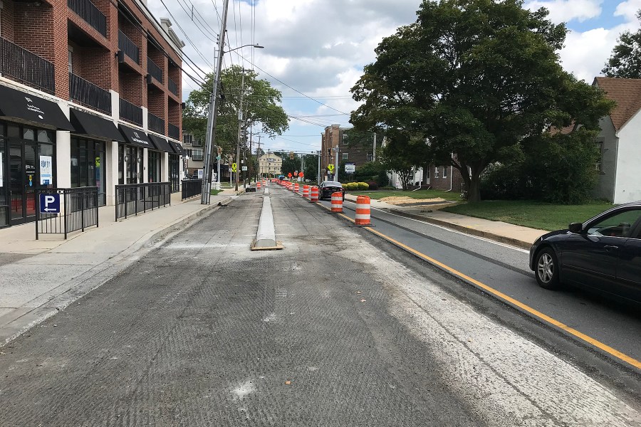
What began as a dream at a BikeNewark (then Newark Bicycle Committee) meeting in 2014 is finally taking shape as part of DelDOT’s Delaware Avenue pave-and-rehab project. Coming on the heels of the massive Main Street renovation, this project includes a major amenity for bicyclists—a two-way separated bikeway (a.k.a. cycletrack)—on the north side of the road.
These photos, taken on July 27, 2022, show the progress along various sections of this major eastbound route through the heart of Newark.
westbound between S. College Ave. and Orchard Rd., showing concrete protected-lane separatoreastbound between Academy St. and Haines St., showing concrete protected-lane separator
This new cycletrack feature, which will be a first of its type in Delaware, will enable legal westbound bicycle traffic from the Pomeroy Trail to Orchard Road. Bike traffic on the western end of this project will be shuttled to/from Orchard Road and Amstel Ave. as a continuation to/from South Main Street.
East of the Pomeroy Trail all the way to Library Avenue, there will be one-way raised lanes on either side of Delaware Avenue.
new island at Pomeroy Trail crossing westbound, marking change from two-way to one-way (WB)westbound at the curve toward Newark Transit Hub, showing raised bike lanes (in black)eastbound at the curve toward Newark High School, showing raised bike lanes (in black)
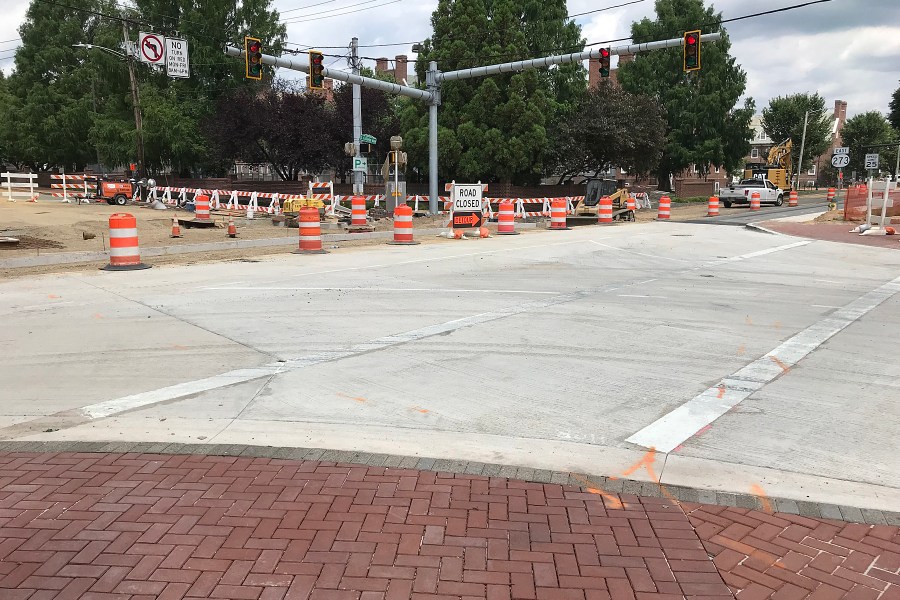
The other notable new feature will be the raised-profile intersection at South College Avenue. This feature will help pedestrians walk across at the sidewalk level, eliminating potential curb missteps and will also act as a traffic-calming aid.
raised intersection (south half) at South College Avenue, level with sidewalks
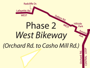
Just before the new year, the City of Newark completed installation of wayfinding signage for the West Bikeway segment of the Newark Bikeways low-stress network.
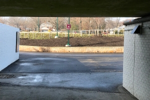
Westbound entry to Hillside Park from the railroad tunnel
This work came on the heels of the opening of the long-awaited Hillside Park, built on the former grounds of the University of Delaware’s Rodney residence halls complex.
Westbound Hillside Park sign looking onto Dallam Rd.
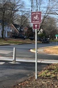
As a result of this work, bicyclists can take a low-stress route from Orchard Road on the Central Loop westward to Casho Mill Road—down Amstel Ave., through the railroad tunnel, Hillside Park, and the Oaklands and Nottingham Green neighborhoods.
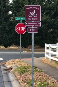
Terminus of the West Bikeway at Casho Mill Rd.
On Casho Mill Road, just south of the end of the bikeway segment is John R. Downes Elementary School. This segment should be widely used by elementary school children who can bike to/from school through the neighborhoods it bisects. Buffered bike lanes on Casho Mill Road will help keep young bicyclists safe on the short ride to/from Lafayette Road.
Destination signage eastbound on Dallam Rd.
Eastbound (i.e., toward the city center and Central Loop Bikeway), signage includes directional symbols or destination information.
Map of the West Bikeway segment
Thanks goes to Delaware Greenways for its generous grant to BikeNewark, which partially funded our “phase 2” signage—for the North, Northwest, and West Bikeways segments—as well as to the White Clay Bicycle Club for its monetary support, and to the City of Newark for installing the signage.
Nearly four years after initial meetings about submitting a Safe Routes to School grant application for a project on Casho Mill Road, things are finally taking (physical) shape. Striping has been added recently, and more will be added until this initial phase of the project is complete.
The project area is between Church Road and Pickett Lane.
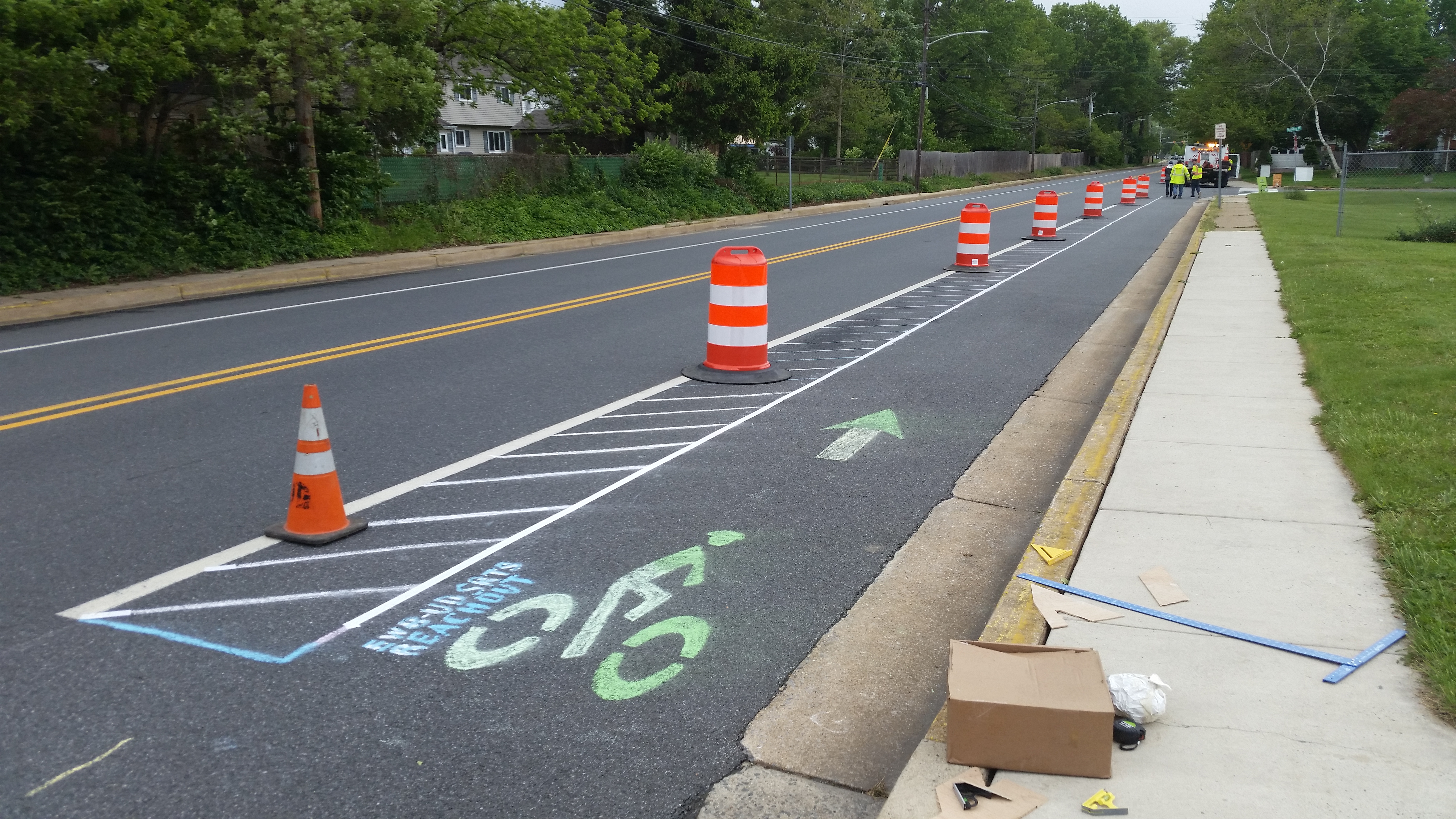
Buffered lane demonstration, 2017
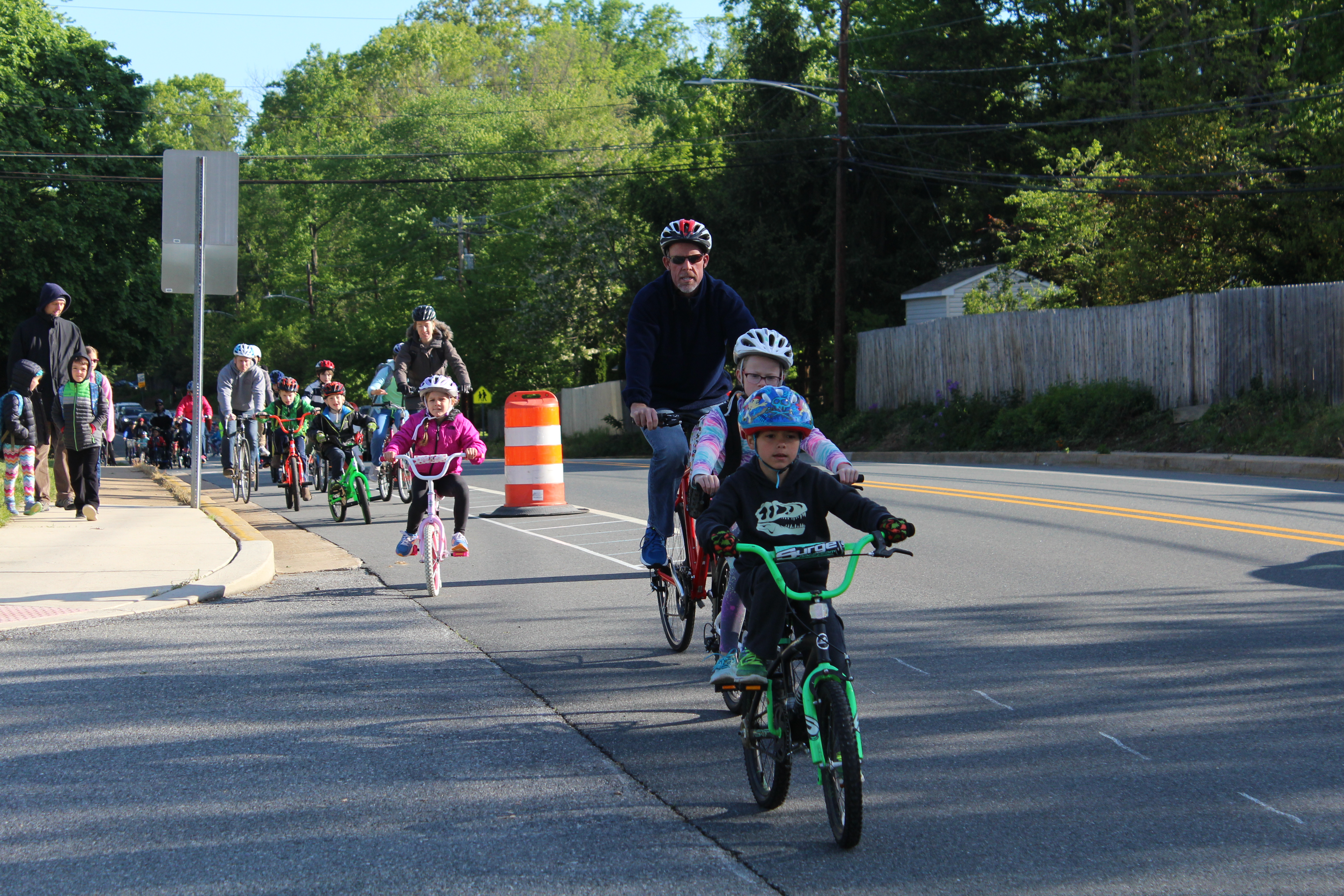
For a Bike to School event at John R. Downes Elementary School back in 2017, BikeNewark worked with volunteers from the University of Delaware’s chapter of Engineers Without Borders, who created pop-up buffered bike lanes to demonstrate how a finished project might look along this busy suburban road on which the school is located.
School children arriving by bike, 2017
City of Newark staff have repeatedly noted that motorized traffic continues to dash along Casho Mill Road above the posted 30mph speed limit. Public Works & Water Resources Director Tim Filasky, who is one of BikeNewark’s partner liaisons, says, “It just feels like a freeway. This will tighten it up and slow traffic.” Ultimately, the City would like to have the speed limit reduced to 25mph, as it is on sections of Casho Mill Road on either end (north and south) of the project area.
Motorist’s view of buffered bike lanes along Casho Mill Road, showing only a slight reduction in vehicle lane width while providing ample buffer for cyclists
BikeNewark has been involved from the inception of the effort, in coordination with the City, the school, Downes parents, WILMAPCO, and DelDOT. The idea is to make bicycling safer (especially for school children and their parents) and encourage more students in this vast residential area to ride a bike to school, rather than be transported there by car.
When the project is completed near the end of 2020 [now expected fall of 2021], it will include a new crosswalk, a pedestrian-refuge island, curb ramps, traffic-calming islands, and radar-detected-speed signs.
BikeNewark’s planned West Bikeway (a segment of its Newark Bikeways low-stress network project) will intersect Casho Mill Road (and these SRTS amenities) at Lafayette Road and provide signed low-stress access to the school through the Oaklands and Nottingham Green residential neighborhoods.