- Newark Bikeways
- Wyoming Road corridor improvements
- Emerson Bridge and Pomeroy Trail connector paths
- Delaware Avenue two-way protected bikeway
- Main Street contraflow bike lane
- Old Newark pop-up mini-circle demonstration
- Downes Safe Routes to School grant
- Cleveland Avenue improvements
Newark low-stress bikeway network: Newark Bikeways
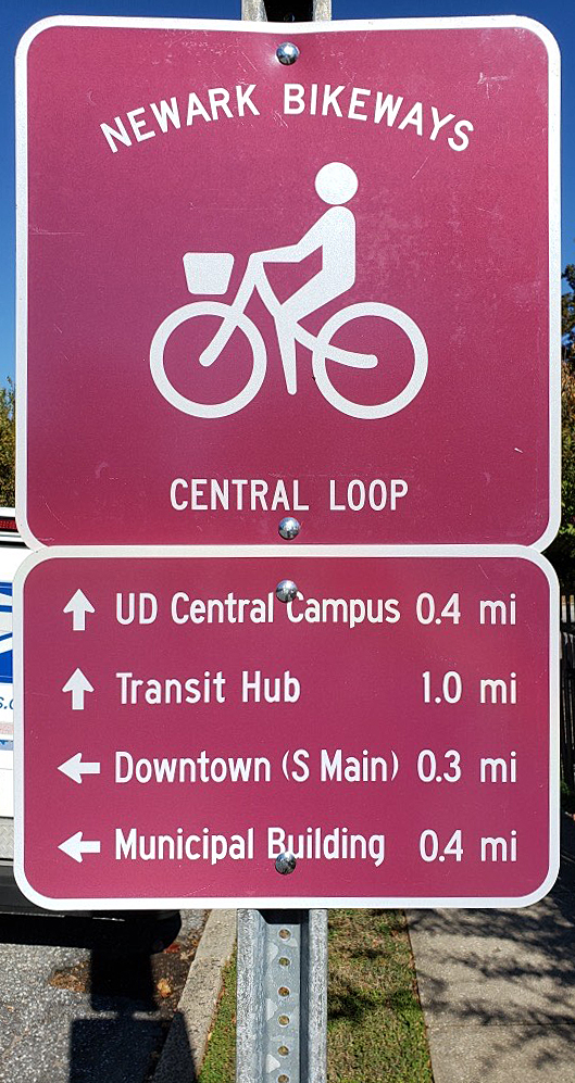
> view Bikeways map (PDF)
Consistent with recommendations in the 2014 Newark Bicycle Plan, BikeNewark’s Engineering Committee began discussion in summer 2016 about designing a low-stress bicycle network for Newark.
In 2017, BikeNewark continued to refine vision drafts and plan for this low-stress network and related wayfinding amenities and confirmed with DelDOT that our plans were consistent with its level-of-stress data.
In 2018, a “Central Loop” was identified as “Phase 1” of this network, and signage was added to this core bikeway in 2019, with the exception of the Delaware Avenue portion.
The pandemic greatly stalled work during 2020.
Early in 2021, BikeNewark received a generous grant from Delaware Greenways’ Future Trails of Northern Delaware Coalition as well as private donations to help fund “Phase 2.” In the spring of 2021, wayfinding signs for two more segments—the North Bikeway and Northwest Bikeway—were installed. Signs for the third of the “Phase 2” segments—the West Bikeway—were installed at the end of 2021.
In 2022, BikeNewark ordered signage for the Southwest Bikeway (which includes an off-road bike/ped pathway), and the City installed signage where it could while DelDOT was still working on completing its massive overhaul of Elkton Road. Installation of these wayfinding signs was completed in the fall of 2022.
In 2023, BikeNewark worked with City staff to have signage installed for the South Bikeway and the portion of the Central Loop that corresponds to the Delaware Avenue two-way protected bikeway.
In 2024 the City installed four information kiosks in specific bikeway locations—the junction of the Central Loop and the Southeast Bikeway (in Phillips Park), on the North Bikeway (in Olan Thomas Park at the future junction of the Northeast Bikeway), on the Central Loop at the junction of the Hall and Pomeroy Trails, on the West Bikeway (in Hillside Park). These kiosks were funded through generous grants from The Newark Partnership and State Rep. Cyndie Romer.
BikeNewark continues to collaborate with City staff to plan for and add wayfinding signage to the two remaining Bikeway segments—Northeast and East—in the proposed network. Wayfinding signage for these three bikeways will follow as funding permits and necessary DelDOT and City projects are completed.
> view Bikeways map (PDF).
Wyoming Road corridor improvements
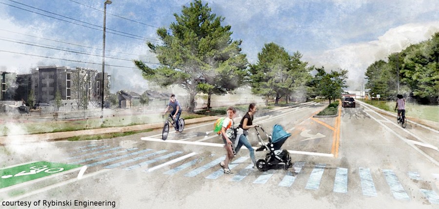
In March 2023, it was announced that the City of Newark and DelDOT had finalized its Transportation Improvement District (TID) project list. Among the potential $59 million in total projects, an estimated $7.1 million would be allocated to create protected bike lanes along Wyoming Road in both directions from the UD East Campus to Marrows Road. This is in addition to two other related TID projects—construction of a traffic circle at South Chapel Street, and intersection improvements at Library Avenue.
> See March 2023 Newark Post article.
At BikeNewark’s May 2022 partnership meeting, Rybinski Engineering shared a presentation on the preliminary design work it had done for the City of Newark on possible bicycle-centric improvements along the busy Wyoming Road corridor. This work was the result of a $15,000 Delaware Bicycle Council grant the city received, the application for which was co-written by BikeNewark in 2020. The City is planning to coordinate this project within its Transportation Improvement District and fund appropriately.
> See June 2022 Newark Post article.
Wyoming Road has long been a concern and had been identified in a recommendation for improvement in the 2014 Newark Bicycle Plan. Most recently, improvements for the Library Road / Wyoming Road intersection (D on map below) were the subject of a 2020 session of the Designing Delaware Intersections for People summit in Dover.
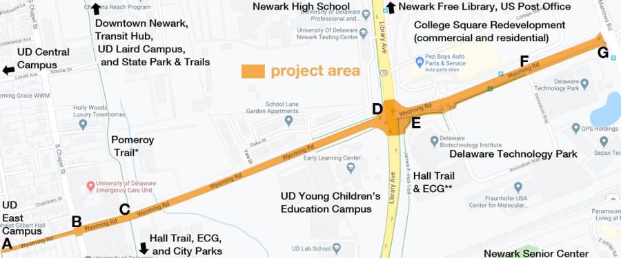
BikeNewark had long thought that, with the 400+ residents at The Grove (near F on the above map), there would be substantially more volume on this road, including bicyclists heading to and from the University of Delaware campus. There was also a concern for cyclists for a realignment of the intersection at South Chapel Street.
Therefore, we wanted to see something done to increase safety for bicyclists along this ultra-wide street. In addition, we feel that such an improvement project would align well with our low-stress bikeway network development (our proposed East Bikeway) and make it possible for the East Coast Greenway (ECG) to be rerouted from Library Avenue onto Wyoming Road and then onto the Pomeroy and Hall Trails, creating a more efficient and easier-to-navigate ECG route through Newark.
Emerson Bridge and Pomeroy Trail connector paths
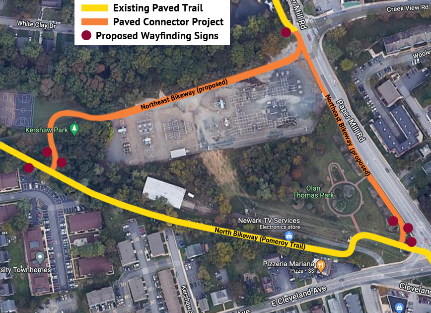
Following the 2022 completion of the Emerson (bike/ped) Bridge, the City is moving forward with plans to have DelDOT construct two off-road paved trails, one through Kershaw Park and the other through Olan Thomas Park, which will connect the bridge with the Pomeroy Trail. The project began in January 2023 with a meeting of engineering representatives from Pennoni Associates, City staff, and members of BikeNewark to discuss design project issues and parameters.
Along with generous funding from New Castle County, project funding had been earmarked in the City’s 2023 budget. It is anticipated that this project will be completed in 2026.
This project has long been in BikeNewark’s plans for connecting the bridge to its North Bikeway and adding wayfinding signage north and east through Curtis Mill Park and along Old Paper Mill Road, thus completing the Northeast Bikeway segment of the Newark Bikeways low-stress network.
Delaware Avenue two-way protected bikeway
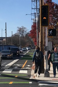 One of the recommendations in the 2014 Newark Bicycle Plan was to create a two-way protected bikeway (a.k.a. “cycletrack”) along Delaware Avenue. The completion of this project enabled legal contraflow bicycle traffic flow from east to west in the heart of the city, which was needed as a lower-stress alternative to riding west with the sharrows on Main Street. While this is the second such bit of infrastructure in the state, it is the longest and largest two-way protected bikeway in Delaware.
Project history and features
This project began to gain traction in June 2014 as BikeNewark (in its former incarnation as the Newark Bicycle Committee) agreed to make the Delaware Avenue cycletrack a top infrastructure priority.
> See excerpt from June 2014 partnership meeting minutes (PDF)
The City subsequently hired Johnson, Mirmiran & Thompson (JMT) to do the feasibility study. BikeNewark members and partner liaisons were involved in JMT’s collaborative stakeholder work group.
Detailed engineering design plans were completed by the end of 2019, and a $7.66 million contract for construction was awarded in October 2021. Construction on Delaware Avenue began in the late fall of 2021. This project, which followed the Main Street reconstruction/repaving project, was completed in 2022.
Unlike the original concept photo above, the cycletrack features a three-inch-high beveled 18-inch-width curb separator from Orchard Road to the Pomeroy Trail. This was a design enhancement accepted by DelDOT at the suggestion of experts from the Netherlands as a result of presentations and discussions at the 2019 Delaware Walkable/Bikeable Summit.
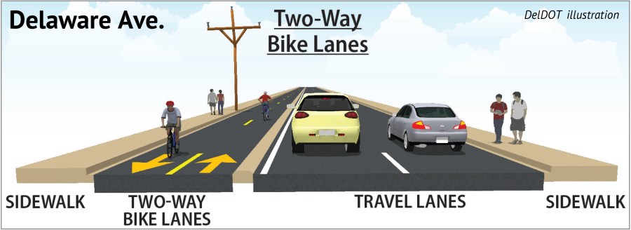
Other features include raised one-way bike lanes on either side of the road from the Pomeroy Trail to Library Avenue, a slightly raised intersection at South College Avenue, crossing amenities at Amstel Avenue and South Main (not part of the original plan), green surface paint at points of conflict with motorists (e.g., driveways), and bicycle-specific traffic signals.
The completion of this project also completes the final segment of BikeNewark’s Central Loop Bikeway, the hub of the Newark Bikeways low-stress network.
Main Street contraflow bike lane
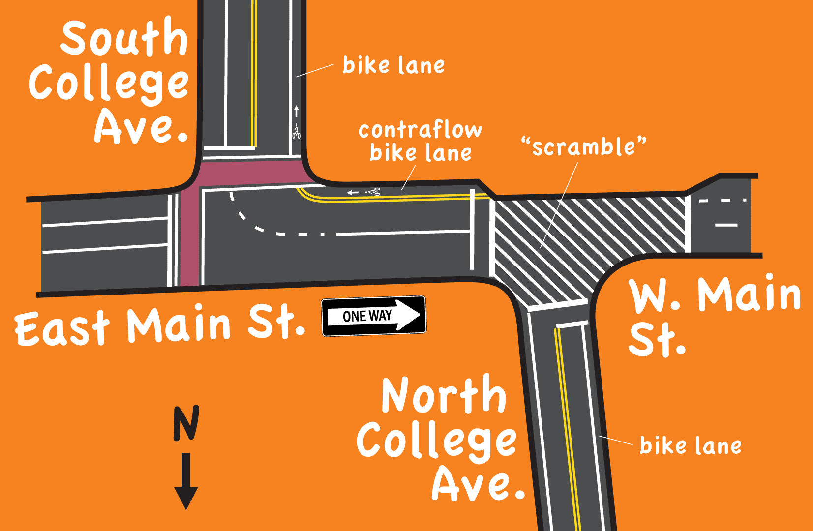 In May 2017, the City of Newark Traffic Committee heard a proposal for and discussed the trial of a contraflow bicycle lane on East Main Street between North College Avenue and South College Avenue.
 After much discussion and some compromising on BikeNewark’s proposal, the Traffic Committee OK’d a contraflow-lane trial from mid-August through the spring 2018 semester.
The concept agreed upon was that bicyclists would remain in the current bike lane southbound on North College Avenue and be allowed to make a left into a designated contraflow lane only during the pedestrian-scramble signal phase (solid red+red arrow) and only while yielding to pedestrians (understanding that while cyclists are moving through the scramble on that signal phase, they are legally considered “pedestrians”).
During that phase, they may also either turn right heading west on West Main Street or move straight across the intersection and then dismount, in accordance with University of Delaware rules and Newark law. Once in the contraflow lane, bicyclists will have to yield to pedestrians crossing South College Avenue in the East Main Street crosswalk before turning right into the South College Avenue bike lane.
During the other two signal phases (solid red and green right arrow), only right turns can be made from the North College Avenue bike lane and only after a full stop on solid red (just like cars).
 DelDOT applied paint and installed signage, and BikeNewark produced a short educational video (above) and an info flyer (right) to share with the community. BikeNewark’s aim was that, combined with the educational piece, this infrastructure amenity would have a positive effect on behavior and safety at that intersection while providing bicyclists with a legal means of navigating north to south without having to dismount.
During the ensuing weeks, BikeNewark members observed behavior at a number of times during the day on random days of the week. Data proved conclusively that this contraflow lane was working pretty much as intended. BikeNewark subsequently recommended to the City of Newark that it make this a permanent amenity on Main Street.
Old Newark pop-up mini-circle demonstration
 In 2017, the Friends of Newark Neighborhood Streets (FONNS) citizens group and the City of Newark developed a pop-up mini-circle demonstration at the intersection of Orchard Road and Winslow Road in the Old Newark neighborhood. BikeNewark was represented at FONNS project committee meetings to consult on and support the project.
This project came about as a combination of long-standing resident concern over frequent traffic-speed and stop-sign violations (need for traffic calming) and BikeNewark’s longer-term vision that Orchard Road become part of a comprehensive low-stress bicycle network in Newark (fewer four-way stop signs in a quiet neighborhoods). For details on the project, see the mini-circle demonstration page.
Downes Safe Routes to School grant
 Striping for buffered bike lanes were applied in August 2020, and traffic-calming islands were subsequently added in early 2022 to Casho Mill Road between Church Road and Pickett Lane. This marks the completion of a years-long Safe Routes to School project for which John R. Downes Elementary School was awarded a grant.

The intent of the project along this heavily traveled stretch of road on which the school is located was to provide a more comfortable and safer ride for kids and parents to and from the adjoining neighborhoods and keep bicycle traffic riding in the proper direction (with traffic).
In addition, the traffic-calming measures that have been implemented—lane narrowing, center island(s), visible buffer striping—are meant to eventually enable DelDOT to lower the speed limit along this portion of the road to 25 mph, consistent with the portions of the road that bookend the project section.
Background
DelDOT provided a series of public workshops and afterward presented at City Council for community members who aren’t affiliated with Downes. One of the original three options that the SRTS Committee, which included BikeNewark representatives, was presented.
Subsequently, a former City Council member had recommended city funding be allocated for more traffic-calming islands, in addition to the single, planned crossing island, along the length of the project (on Casho Mill Road between Church Road and Pickett Lane).
Cleveland Avenue improvements
 The repaving of Cleveland Avenue began in the summer of 2018 and continued, section by section, until completed. In an initial stage, the section between Paper Mill Road and Capitol Trail (Kirkwood Highway) was transformed from a four-lane road to a two-lane road with middle turn lane and bike lanes and two crossing islands. Prior to this facelift, City Council took DelDOT’s recommendation to make Margaret Street one way northbound and install a traffic signal at Creek View Lane and Paper Mill Road.
As a precursor to work done on the block between North College Avenue and Paper Mill Road, City Council voted to remove on-street parking. The remainder of the work on Cleveland Avenue was completed in 2022. Now, the entire length of Cleveland Avenue has bike lanes in both directions (except for lane-sharing conditions at and nearing intersections and at a single mid-block crossing island).
Potential project redesign of the Paper Mill Road/North Chapel Street intersection (see photo above) with Cleveland Avenue had been one of the topics of Bike Delaware’s Designing Delaware Intersections for People conference in November 2020. However, this was never part of the original DelDOT project.
Project History
Ahead of this DelDOT pave and rehabilitation project along the length of Cleveland Avenue, BikeNewark (in its former incarnation as the Newark Bicycle Committee) came up with a list of potential improvements to the corridor (New London Rd. to Kirkwood Hwy.) and urged the City to form a task force of stakeholders to help make some preliminary decisions that would benefit all.
 The Cleveland Avenue Improvements Task Force met several times during an eight-month period and subsequently presented its final recommendations to the City’s Traffic Committee for its consideration. In October 2016, the Traffic Committee approved all ten recommendations to be sent to City Council for its deliberation and decision.
On Monday, July 10, 2017, City Council voted 6-1 to ban on-street parking between North College Avenue and North Chapel Street. This was a key ordinance change that was part of the approved set of recommendations and that will facilitate the success of the changes proposed for this corridor. Another piece of the recommendations puzzle was changing Margaret Street to one way north to help simplify the Paper Mill Road intersection. City Council voted in this change unanimously on June 25, 2018.
City Council voted unanimously to approve the entire slate of recommendations at its August 14, 2017, meeting.
